Friday, December 6, 2013

The Earth's uneven heating is due to the fact that the Earth is at a tilted angle. Also, the Earth is a sphere and parts of the world can't all be heated at once. One final example is Earth's optical orbit. It spins and circle in a pattern preventing the whole Earth receiving the same about of heat. A model that help explains this is when in class we held up a globe and had a flashlight shine at the globe. It showed which areas of the earth received direct heat unlike certain parts of the globe received little to none.

The Earth's rotation affects the movement of air and water masses. The way the Earth rotates creates certain movements of air to spiral and create a constant pattern. As well as the water masses, they're affected because of the motion of the Earth. The coriolis effect is when the air spins in a perpendicular way and creates weather patterns. We examined this through cutting out a circle piece of paper and putting a pencil through the middle of the paper. We spun the paper and used a water dropper to drop tiny pieces of water showing us how the water spun around the paper in a spiral effect. Hadley cells are when air rises at the equator and then drops down. Most deserts are found at 30 degrees N or S latitude due to the fact that there is direct sun light hitting those degrees warmer the Earth to an extensive heat.

There are prevailing global wind patterns due to the fact that the Earth is tilted at an angle and certain parts of the Earth receive more sunlight/heat than other sections. Such as the equator. The equator receives the most heat and the doldrums are formed there.  Global wind patterns are prevailing because of the heat the world receives.  As for the westerlies, the weather patterns and airline flights are affected. They are very powerful and can give the plan extra speed due to the strength of the winds. But, once the plane needs to except the wind pattern, it is very difficult because of its strength.  
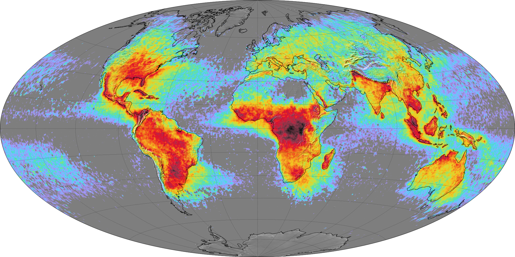


http://eoimages.gsfc.nasa.gov/images/imagerecords/6000/6679/global_lightning_lrg.jpg

Wind patterns might change as a result of global warming because the wind patterns are affected by the climate of the world. Especially at the equator. This article helps support this statement. http://www.climatecentral.org/blogs/climate-in-context-global-warmings-potential-impact-on-wind-energy

Friday, November 22, 2013

Loggerhead Island

1. What special considerations did you have to make for the nesting sea turtle sites located on the barrier island?
We made sure that there was no resorts or a ton of human interaction with the nests of the sea turtles. Also, due to the closeness of the homes, we made a rule stating that there must be dark hours once the sun sets so the turtles aren't drawn to the light of the buildings. The people inside the homes must shut the shades if they're going to have lights on. We also built a tall wall blocking the highway so the turtles aren't drawn to the lights of the cars. 
2. What special considerations had to be made when determining a good site for the proposed fishing pier?
We made sure it wasn't located near the turtles, worms, or other sea creatures that could be affected by the fishing. We also made sure that there was no boating allowed, only kayaking and canoeing. 
3. What could be some of the potential problems that might arise from the proposed golf course? Propose some of the ways in which the impacts can be reduced.
One of the concerns was the golf balls getting hit into the highway or the ocean and the sea creatures trying to eat it. To stop the golf balls from going into the highway we built another decently sized wall to prevent the balls from going into the highway. Also, we made sure that the golf course was far enough from the water so there wouldn't be a chance that it impacts the sea creatures.
4. What are the economic benefits to the community of Loggerhead County if the development was done with the least amount of environmental impact?
The Loggerhead County would be an ecosystem in its self. It would be very peaceful and how the world should truly be treated. The reproduction of the animals wouldn't be altered with nor would our presence create an issue to the island. The island would be a great example for the world to follow. 
5. Describe three ways in which humans negatively impact coastal ecosystems such as the one you are working on with Loggerhead Barrier Island.
Humans often litter their trash outside of their windows, meaning that the animals may attempt to eat it and die. Also, it's not the cleanest way for us to live. Another negative impact is how we don't protect the animals. Such as the sea turtles, we don't make sure that they're safe from people walking over the nests and even drawing them to the cars by the lights instead of being drawn to the ocean. One final negative impact is boating. Boating can kill the sea creatures in the ocean from their propellers.
6. How can maintaining natural vegetation help us to reduce the damage caused by oceanic events such as hurricanes, tsunami and continued beach erosion?
We can keep the shoreline in place making sure we do not disrupt the oceans ways of life.
7. After listening to the other groups make their presentations, were there any ideas they had you would have used if you had though about it before-hand? You should list at least three different ideas and indicate why their idea is actually better for the environment than yours. 
I did not see any other ideas that were better unfortunately, but I was able to come up with better ideas on my own. We could create an rule of absolutely NO LITTERING on the island. We could make the fine very large and threatening. Also, we could use solar panels to be more environmentally friendly. One final idea is to use compost to help the island grow.

Friday, November 1, 2013

What can a grain of sand tell you about the Earth?

You are to describe and discuss the eight sands you examined this week. Start with the table of data you assembled on the eight sands you looked at, and continue by making an interpretation of the environment of two of the sands, how far each traveled, and their ultimate source areas.

Maui: The Maui sand had a mixed color of yellows to blacks. This collection of sand was indeed magnetite and it had a size of 1.5mm a grain. The texture of the sand was subrounded and was sand on the Wentworth Scale. It had well sorting of it's size and was composed entirely of rocks. I believe the environment of the rock was very calm. I think the waves were strong enough to mix around the colors of the rocks, but not that strong to make the shape of the rocks sharp and jagged.

Klamath California: This selection of sand was entirely black. It was very dark. But, when you put a magnet up to the sand, it didn't lift it up, meaning it was not magentic. The size of one grain was 1.5mm and it had an angular texture. Which, I believed was caused from the rough current of the waves crashing the grains on each other making the shape jagged and sharp. Klamath California was sand on the wenworth schale and the size was moderately sorted. The composition consisted of rocks.

Hampton NH: Hampton NH had very light colored grains. Some looked clear and some were pale. It was not magnetic and a grain had the size of 1.0mm. The shape of the grains were angular due to the strong waves lifting the sand and crashing them against one another. It was sand on the Wentworth Scale and was moderately sorted in size. But, of course the composition was made up of rocks.

Salinas: The Salinas consisted of a very light color. It was angular due to the smashing of the waves lifting up the rocks and them grinding against one another. The size of one grain was .33mm, making them very tiny grains composed of rocks. The sorting of the sizes was very well and they all seemed to be the same size. The salinas were not magentic at all.

Edgartown: The Edgartown sands were light in color and subrounded from the soft waves that lifted the rocks and smashed them together smoothly. The sand was not magnetic and was composed of rocks. On the Wentworth scale it was sand. As for the size, a grain was measured to 1.00mm! The sorting all though was okay and there were large, yet tiny pieces of sand.

Virgin: The Virgin sand has really cool colors. Some were light (pale, yellow) and some were dark (Black, brown). It was not magnetic, but it was very angular due to the strong waves making the sands crash hard against each other. It had a measurement of .1mm and it was poorly sorted because some grains were very large in size and some were quite tiny. The compostion of the grains was of rock and on the Wentworth Scale it was considered sand.

Saint Martin: Saint Martin sand was very light in color. It was not magnetic and it was indeed angular from the currents of the waves. It varied in size and the sorting was poor. It was composed of rocks and was sand on the Wentworth scale.

Pine Island: The color of the sand was very clear and beautiful. It was not magenetic and it was subrounded in shape. It was well sorted and it hade a size of .1mm. It was composed of rocks and was sand in the Wentworth Scale.

Friday, October 25, 2013

Sounding the Sea; A Study in Bathymetric Mapping

1.) How can ocean floor features be measured and mapped using current acoustical technology? How can ocean floor maps be used in the commercial, military, and/or private sector?
To map the ocean floors you use the Bathymetric Mapping technique as well as the sonar stick. These two types of equipment help make it possible to map the floor and observe it. As for the commercial, military, and/or private sector they use a sonar stick that shoots sound vibrations down into the ocean to measure the ocean floor.
2.) A flat abyssal plain is when plate tectonics move and sediments fall to the ocean floor making it smooth and flat: ( http://answers.yahoo.com/question/index?qid=20070213213211AAVLLJf )

https://ishtarc.wikispaces.com/file/view/AbyssalPlain.jpg/116248191/384x231/AbyssalPlain.jpg

An underwater seamount or guyot is a flat volcano that is isolated on the ocean floor. It has a flat top that raises from the ground. (http://en.wikipedia.org/wiki/Guyot)

(http://upload.wikimedia.org/wikipedia/commons/a/a4/Bear_Seamount_guyot.jpg)
A submarine canyon on the continental shelf is like a canyon under water. It goes onto the continental shelf and sometimes even leads into rivers. (http://en.wikipedia.org/wiki/Submarine_canyon)

(http://www.dkimages.com/discover/Projects/KA620/previews/20117924.JPG)
3.)
1.)Based on your seafloor model provide a description of the topography of your surveyed area.
Based on the seafloor model we made, it was often flat and consisted around the same depth throughout the box. Some spots were very low, but the majority of the box was consistent and didn't have much holes or mountains.
2.) What are the advantages of using remote sensing technology for your survey instead of direct observation?
We are able to make a more specific observation of how deep the ocean is with the sonar stick. Because with just observation from our eyes can give us the wrong impression of how deep the ocean is, therefore it is very important to use tools such as the sonar stick to give us correct measurements.
3.)What is the advantage of using vertical exaggeration in constructing your profiles of the seafloor?
It gave us more of the understanding of the sea floor. It allowed us to see how the floor blends into things such as a flat abyssal plain and other underwater floor features.
4.) Write two new research questions based on what you have learned from this activity:
           1.) What is the main cause of the ocean floor features?
           2.) If plate tectonics didn't exist, would continents still move?
5.) What was the value and importance of this activity to your study of science?
It was very important to learn why certain underwater features exist and how they form. It's also nice to know how scientists know the exact measurements for how deep the ocean is for certain spots. It's interesting to know that they use sound to help measure that.


Pangea: "The Dancing of the Continents"

This map above is Pangea. Through the activity of the "Dancing of the Continents", I was able to observe where each continent was located and how each of the land formations connected to each other. I learned how they connected and what caused them to split apart. Such as the Theory of Continental Drift. The continents automatically drift because the ocean floor isn't that strong and able to hold the continents still, therefore they moved. Another theory, Theory of Seafloor Spreading, the molten magma causes the plates to push apart, expanding the the ooze causing the continents to move once again. The other theory is Theory of Plate Tectonics. This theory is that there are six plates that push against one another shoving and drifting apart, pulling the continents with it.

Scientists of different disciplines come together observing their different studies to help conclude these theories. They are able to observe the way of the ocean through similar studies, working together to conclude why the continents drift. Each of them have a specific study such as Physicists and oceanographers. Together they can make conclusions with their knowledge of the certain subject which in this case happens to be why Pangea broke apart.

Friday, October 4, 2013

Memorandum

Assignment: "You are a biological oceanographer studying and documenting the breeding habits of a clam that lives in a depth range of 40 to 140 meters. The clams are found only in the South Pacific about seven days sailing from the closest port. The breeding cycle takes place nightly and lasts 4 to 6 hours."

To conduct this experiment, I would first find a group of fellow biological oceanographers willing to help orchestrate the experiment. We would have multiple fundraisers to help raise money for the mission as well as donate personal money to help move the project along. The first step would to talk with the other biological oceanographers about what exactly we want to discover about the breeding habits of a clam to make the time spent under the water worth it. After we discussed the plan, we would build the submersible. The main thing we would need is a room made entirely up of glass for the oceanographers to observe the clams easily. In that room would be cameras to film the process of the breeding habits as well as tables to conduct lab experiments. Through out the submersible would be obvious necessities such as a bedroom, bathroom, kitchen, and a room to enter and exit the submersible. We would all buy the proper equipment to purchase technology useful to conduct and make this mission easier. The submersible would be made strong enough and well built to withstand being under what at 140 meters.

Friday, September 20, 2013

Observatory Installation and The Effects of the Molasses Spill

Observatory Installation Process:
I think it is incredibly time consuming and difficult to build an underwater observatory. You need to take in consideration the monitoring of oxygen levels, how the current will affect the submersible, and the risk of something leaking or water spilling into the submersible. It must take years to correctly build the submersible and multiple tests to make sure that it is 100% ready to go because if they begin the mission and it has a defect. it could end up affecting the entire submersible and ruining parts of it. I think it's crazy how they figure out where certain things should go and how to use certain equipment to get the most information while they are under the water.

The Effects of the Molasses Spill:
I also want to write about the molasses spill that happened in Hawaii. I think it is absolutely unacceptable that that happened. The people moving the molasses to California should have been much more careful with transporting it and watching to make sure it wouldn't spill into the sea. It seems like they were lazy and careless with the transportation and completely ignored the fact that it could spill into the ocean. It's really upsetting to see all of the sea creatures and organisms dying because of carelessness. I hope they figure out how to remove the molasses as soon as possible before more creatures die and before the coral gets destroyed.

Friday, September 13, 2013

Why explore the oceans?

Through the past two weeks I learned that exploring the ocean is very important. Back in the day explorers would leave everything they had at home to stay on a ship for years. They would study the ocean world around them such as the creatures and the land around it. Columbus left and went on a mission to discover new land. He traveled on the ocean to see the creatures, people, and new land. Charles Darwin studied coral reefs on his ship and came up with theories. Without these explorers taking a chance and traveling the ocean, we wouldn't have known the information we know today.

Just by going on trips to the ocean and field trips to study the ocean is important. The majority of the world is made up of the ocean so why not learn about what's in it. All the creatures and traits in the ocean can teach us so many things about the world such as Darwin's theory of natural selection. Just from the ocean he was able to make a theory that would help us not just with the ocean, but with land creatures as well. The ocean is a stepping stone for us to learn more about the world around us. So, learning about the explorers and their discoveries were very important for us. We were able to learn about what they discovered and how. It was a huge mark in history with all of the expeditions because it helped bring us to where we are today.

Friday, September 6, 2013

Why study Oceanography?

The reason why I decided to take Oceanography as an elective is because of my fascination of the ocean. I have spent every summer of my life living on the ocean. Ever since I was little I loved watching the waves and examining the sea creatures. When I saw that my school was offering Oceanography and Marine Biology as a class, I couldn't let the opportunity pass. Studying science is important because we were blessed with this exciting world, so why not take the opportunity to learn about the world we live on. I hope to learn how the ocean impacts the world we live on and the secrets it may have in store for us.